FAQ/ The coordinate systems available in DioVISTA are
What coordinate systems can I use in DioVISTA?
Can I use the "Standard Area Mesh (Tertiary Mesh)", which is one of the latitude-longitude coordinate systems?
response
You can use the Standard Region Mesh (Tertiary Mesh).
DioVISTA uses either a UTM coordinate system or a standard area mesh.
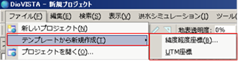
How to select a coordinate system
Choose either menu [file] >[Create new from template]> [Latitude-longitude coordinate system] or [UTM coordinate system] .
Whichever coordinate system you choose, you can convert it to a Standard Area Mesh when exporting simulation results.
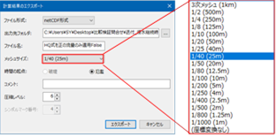
How to Export Simulation Results with "Standard Region Mesh"
[Export in MLIT format] In the dialog [Mesh Size] , choose one [Third-order mesh (1km)] of the following [1/1000 (1m)] :
If[(no transformation)] you select , the coordinates will not be converted.
In the work of creating flood prediction area maps, delivery in the "Standard Area Mesh (Third Mesh)" is required by the "Guidelines for Digitization of Flood Expected Area Map Data (3rd Edition)". DioVISTA allows you to output in a coordinate system that conforms to these guidelines.