FAQ/ Conversion from ASC format to importable NetCDF format
Technical Reference Input/Output function/ Terrain, roughness, and embankment import function/ NetCDF format How do I create an importable netCDF file?
response
There are several ways to create a netCDF.
- How to convert a text file to netCDF format using a tool called ncgen.exe
- How to export mesh data in ASC format using GIS software such as QGIS and netCDF format using programming languages such as PowerShell
Here we will talk about the second method. For the first method, please refer to this article.
-
Data such as topography, roughness, embankment, etc. are created using GIS software and created in ESRI ASC Raster format.
Here is some sample data: Save these files to your desktop.substance Sample Elevation data glev_asc.txt Roughness data roughness_asc.txt Embankment top data leveeHeight_asc.txt Embankment flag data leveeFlag_asc.txt -
Install PowerShell.
From the Microsoft Store, install PowerShell.
If you want to install without using the Microsoft Store, see Install PowerShell on Windows. -
Install the netCDF library.
Get the netCDF4 64-bit version from the Installing and Using netCDF-C Libraries in Windows website of the official NetCDF website.
The latest version as of October 2021 is netCDF4.8.0-NC4-64.exe.
The following instructions assume that this version 4.8.0 is installed.
By defaultC:\Program Files\netCDF 4.8.0\, the netCDF library is installed. -
Install the netCDF library for PowerShell.
Download NetcdfCs.dll andC:\Program Files\netCDF 4.8.0\bincopy it to .
If necessary, use the . NET 5.0. Install .NET on Windows -
Create a PowerShell script. Here is a sample:
  1
  2
  3
  4
  5
  6
  7
  8
  9
 10
 11
 12
 13
 14
 15
 16
 17
 18
 19
 20
 21
 22
 23
 24
 25
 26
 27
 28
 29
 30
 31
 32
 33
 34
 35
 36
 37
 38
 39
 40
 41
 42
 43
 44
 45
 46
 47
 48
 49
 50
 51
 52
 53
 54
 55
 56
 57
 58
 59
 60
 61
 62
 63
 64
 65
 66
 67
 68
 69
 70
 71
 72
 73
 74
 75
 76
 77
 78
 79
 80
 81
 82
 83
 84
 85
 86
 87
 88
 89
 90
 91
 92
 93
 94
 95
 96
 97
 98
 99
100
101
102
103
104
105
106
107
108
109
110
111
112
113
114
115
116
117
118
119
120
121
122
123
124
125
126
127
128
129
130
131
132
133
134
135
136
137
138
139
140
141
142
143
144
145
146
147
148
149
150
151
152
153
154
155
156
157
158
159
160
161
162
163
164
165
166
167
168
169
170
171
172
173
174
175
176
177
178
179
180
181
182
183
184
185
186
187
188
189
190
191
192
193
194
195
196
197
198
199
200
201
202
203
204
205
206
207
208
209
210
211
212
213
214
215
216
217
218
219
220
221
222
223
224
225
226
227
228
229
# 入力ファイル $GlevAscFile = Get-Item "glev_asc.txt" $roughnessAscFile = Get-Item "roughness_asc.txt" $leveeHeightAscFile = Get-Item "leveeheight_asc.txt" $leveeFlagAscFile = Get-Item "leveeflag_asc.txt" # 出力ファイル $ncFileName = Join-Path (Get-Location) "DiovistaDomainData.nc" # dllファイル $dllFileName = Get-Item "C:\Program Files\netCDF 4.8.0\bin\netcdfCs.dll" [void]([System.Reflection.Assembly]::LoadFile($dllFileName)) # エラー時停止 $ErrorActionPreference = "Stop" enum NcType { NC_BYTE = 1 NC_SHORT = 3 NC_INT = 4 } class AscData { [System.IO.FileInfo]$file [int]$ncols [int]$nrows [double]$xllcorner [double]$yllcorner [double]$dx [double]$dy [double]$nodataValue [double[]] $data [int[]] $intData [int16[]] $shortData [byte[]] $byteData [int]$validMin [double]$scaleFactor # ctor AscData([System.IO.FileInfo]$file, [NcType]$ncType, [int]$validMin, [double]$scaleFactor) { $this.file = $file $this.validMin = $validMin $this.scaleFactor = $scaleFactor $scaleFactorInverse = 1.0 / $scaleFactor $headerLines = 7 $lines = Get-Content -Encoding utf8 $this.file.FullName foreach ($headerLine in $lines[0..($headerLines - 1)]) { $header = $headerLine -split " +" if ($header[0] -like "NCOLS") { $this.ncols = $header[1] } elseif ($header[0] -like "NROWS") { $this.nrows = $header[1] } elseif ($header[0] -like "XLLCORNER") { $this.xllcorner = $header[1] } elseif ($header[0] -like "YLLCORNER") { $this.yllcorner = $header[1] } elseif ($header[0] -like "DX") { $this.dx = $header[1] } elseif ($header[0] -like "DY") { $this.dy = $header[1] } elseif ($header[0] -like "NODATA_VALUE") { $this.nodataValue = $header[1] } else { throw [System.Exception] (("{0}: found not supported header: {1}" -f $this.file, $header[0])) } } $this.DumpHeader() $this.data = New-Object double[] ($this.ncols * $this.nrows) for ($j = 0; $j -lt $this.nrows; $j++) { $ws = $lines[$j + $headerLines] -split " +" $i0 = $j * $this.ncols for ($i = 0; $i -lt $this.ncols; $i++) { $this.data[$i0 + $i] = $ws[$i] } } if ($ncType -eq [NcType]::NC_BYTE) { $this.byteData = New-Object byte[] ($this.ncols * $this.nrows) for ($k = 0; $k -lt $this.data.Length; $k++) { $value = $this.data[$k] if ($value -eq $this.nodataValue) { $this.byteData[$k] = 0; } else { $this.byteData[$k] = $value } } } elseif($ncType -eq [NcType]::NC_SHORT) { $this.shortData = New-Object int16[] ($this.ncols * $this.nrows) for ($k = 0; $k -lt $this.data.Length; $k++) { $value = $this.data[$k] if ($value -eq $this.nodataValue) { $this.shortData[$k] = $validMin - 1; } else { $this.shortData[$k] = [int16]($value * $scaleFactorInverse) } } } elseif($ncType -eq [NcType]::NC_INT) { $this.intData = New-Object int[] ($this.ncols * $this.nrows) for ($k = 0; $k -lt $this.data.Length; $k++) { $value = $this.data[$k] if ($value -eq $this.nodataValue) { $this.intData[$k] = $validMin - 1; } else { $this.intData[$k] = [int]($value * $scaleFactorInverse) } } } } [void] DumpHeader() { $message = "file: {0}`n" -f $this.file.FullName $message += "ncols: {0}`n" -f $this.ncols $message += "nrows: {0}`n" -f $this.nrows $message += "xllcorner: {0}`n" -f $this.xllcorner $message += "yllcorner: {0}`n" -f $this.yllcorner $message += "dx: {0}`n" -f $this.dx $message += "dy: {0}`n" -f $this.dy $message += "nodataValue: {0}`n" -f $this.nodataValue Write-Host $message } } # load asc files $GlevAsc = New-Object AscData($GlevAscFile, [NcType]::NC_INT, -100000, 0.01) $roughnessAsc = New-Object AscData($roughnessAscFile, [NcType]::NC_SHORT, 0, 0.001) $leveeHeightAsc = New-Object AscData($leveeHeightAscFile, [NcType]::NC_INT, -100000, 0.01) $leveeFlagAsc = New-Object AscData($leveeFlagAscFile, [NcType]::NC_BYTE, 0, 1.0) $asc = $GlevAsc # create netcdf file $ncFile = New-Object netcdfCs.NcFile if ((Test-Path $ncFileName) -eq $true) { Remove-Item $ncFileName } # Options(bool isNetCDF4, bool forceOverwrite, int compressionLevel $ncOption = New-Object NetcdfCs.NcFile+Options($true, $true, 6) $ncFile.Create($ncFileName, $ncOption) Write-Host ("Create {0}" -f $ncFileName) # global attributes # 表 9(1)ファイル識別子 [void]$ncFile.AddAttribute("title", [netcdfCs.NcType]::NC_CHAR, "DioVISTA calculation domain data") # 使用するnetcdf規約のバージョン(CF-1.6) [void]$ncFile.AddAttribute("Conventions", [netcdfCs.NcType]::NC_CHAR, "CF-1.6") # その他コメント [void]$ncFile.AddAttribute("comment", [netcdfCs.NcType]::NC_CHAR, ("generated on {0} by netcdfPs1_Convert-From-Asc-To-DiovistaDomainNc.ps1" -f (Get-Date))) # dimensions $dimLon = $ncFile.AddDimension("lon", $asc.ncols) $dimLat = $ncFile.AddDimension("lat", $asc.nrows) # variables $varLon = $ncFile.AddVariable("lon", [netcdfCs.NcType]::NC_SHORT, $dimLon.DimId) [void]$varLon.AddAttribute("add_offset", [netcdfCs.NcType]::NC_DOUBLE, $asc.xllcorner + $asc.dx * 0.5) [void]$varLon.AddAttribute("scale_factor", [netcdfCs.NcType]::NC_DOUBLE, $asc.dx) [void]$varLon.AddAttribute("units", [netcdfCs.NcType]::NC_CHAR, "degrees_east") $varLat = $ncFile.AddVariable("lat", [netcdfCs.NcType]::NC_SHORT, $dimLat.DimId) [void]$varLat.AddAttribute("add_offset", [netcdfCs.NcType]::NC_DOUBLE, $asc.yllcorner + $asc.dy * 0.5) [void]$varLat.AddAttribute("scale_factor", [netcdfCs.NcType]::NC_DOUBLE, $asc.dy) [void]$varLat.AddAttribute("units", [netcdfCs.NcType]::NC_CHAR, "degrees_north") $varGlev = $ncFile.AddVariable("glev", [netcdfCs.NcType]::NC_INT, ($dimLat.DimId, $dimLon.DimId)) [void]$varGlev.AddAttribute("valid_min", [netcdfCs.NcType]::NC_INT, [int]$GlevAsc.validMin) [void]$varGlev.AddAttribute("scale_factor", [netcdfCs.NcType]::NC_DOUBLE, $GlevAsc.scaleFactor) [void]$varGlev.AddAttribute("units", [netcdfCs.NcType]::NC_CHAR, "m") $varRoughness = $ncFile.AddVariable("roughness", [netcdfCs.NcType]::NC_SHORT, ($dimLat.DimId, $dimLon.DimId)) [void]$varRoughness.AddAttribute("valid_min", [netcdfCs.NcType]::NC_SHORT, [int16]$roughnessAsc.validMin) [void]$varRoughness.AddAttribute("scale_factor", [netcdfCs.NcType]::NC_DOUBLE, $roughnessAsc.scaleFactor) [void]$varRoughness.AddAttribute("units", [netcdfCs.NcType]::NC_CHAR, "m^(-1/3).s") $varLeveeHeight = $ncFile.AddVariable("leveeHeight", [netcdfCs.NcType]::NC_INT, ($dimLat.DimId, $dimLon.DimId)) [void]$varLeveeHeight.AddAttribute("valid_min", [netcdfCs.NcType]::NC_INT, [int]$leveeHeightAsc.validMin) [void]$varLeveeHeight.AddAttribute("scale_factor", [netcdfCs.NcType]::NC_DOUBLE, $leveeHeightAsc.scaleFactor) [void]$varLeveeHeight.AddAttribute("units", [netcdfCs.NcType]::NC_CHAR, "m") $varLeveeFlag = $ncFile.AddVariable("leveeFlag", [netcdfCs.NcType]::NC_BYTE, ($dimLat.DimId, $dimLon.DimId)) [void]$varLeveeFlag.AddAttribute("flag_meanings", [netcdfCs.NcType]::NC_CHAR, "east north") $flagMasks = New-Object byte[] (2) $flagMasks[0] = 1 $flagMasks[1] = 2 [void]$varLeveeFlag.AddAttribute("flag_masks", [netcdfCs.NcType]::NC_BYTE, $flagMasks) $ncFile.SaveDefinitions() # Write-Host "Save Definitions" # set variable data # x $shortData = New-Object int16[] $dimLon.Length for ($i = 0; $i -lt $asc.ncols; $i++) { $shortData[$i] = $i } $varLon.Values = $shortData $varLon.SaveData($ncFile.NcId) # y $shortData = New-Object int16[] $dimLat.Length for ($j = 0; $j -lt $asc.nrows; $j++) { $shortData[$j] = $asc.nrows - 1 - $j } $varLat.Values = $shortData $varLat.SaveData($ncFile.NcId) # Glev $varGlev.Values = $GlevAsc.intData $varGlev.SaveData($ncFile.NcId) # roughness $varRoughness.Values = $roughnessAsc.shortData $varRoughness.SaveData($ncFile.NcId) # leveeheight $varLeveeHeight.Values = $leveeheightAsc.intData $varLeveeHeight.SaveData($ncFile.NcId) # leveeheight $varLeveeFlag.Values = $leveeflagAsc.byteData $varLeveeFlag.SaveData($ncFile.NcId) $ncFile.Close() # Write-Host ("Close {0}" -f $ncFileName)- In lines 2~5, specify the file to be entered.
- On line 8, specify the full path of the file to output. Here,
DiovistaDomainData.ncwe have set to output to the desktop. - On line 11, specify the path to the netCDF library for PowerShell that you installed in step 2. Here,
"C:\Program Files\netCDF 4.8.0\bin\netcdfCs.dll"we specify . - Paste the script into a text editor and save it as a file name on your desktop
netcdfPs1_Convert-From-Asc-To-DiovistaDomainNc.ps1.
-
Run the script in PowerShell.
Press + R and type in the dialog that appears [Run]pwsh.
When PowerShell starts, copy and paste the following string to run it:1 2 3
cd $env:USERPROFILE\Desktop
Set-ExecutionPolicy RemoteSigned -Scope Process
.\netcdfPs1_Convert-From-Asc-To-DiovistaDomainNc.ps1
is created on your desktop DiovistaDomainData.nc .
-
Bring the created netCDF into DioVISTA.
- Launch DioVISTA.
-
Select Menu [file] > > [Create new from template] [Latitude and longitude coordinates] >.

-
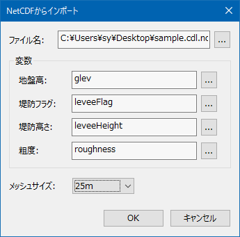
Select Project > [Calculation area] > [Import from NetCDF] .

-
Specify for the file name of the dialog that appears
DiovistaDomainData.nc.
Specify a mesh size of 25 m.

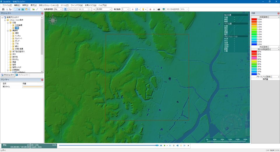
- Data has been ingested into DioVISTA.
