Project/ Rainfall
Main applications
- Used to specify rainfall areas and rainfall.
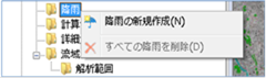 Figure: Rainfall
Table: Rainfall context menu items and functions
| Context menu items | function |
|---|---|
| Creating new rainfall | Create a new rainfall area. |
| Remove all rainfall | Remove all rainfall. |
Creating new rainfall
-
Specify the area on the map where you want to create rainfall with a mouse click.
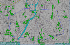
Figure: Specify areas to create rainfall -
To revert to the previous state, right-click or[BackSpace] press the key.
-
To cancel the creation,[Esc] press the key.
-
Confirm with double click or enter.
-
Set rainfall conditions on the Properties screen.
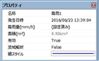 Figure: Properties screen of rainfall condition settings
Table: Rainfall property names and settings
| Property Name | What to set |
|---|---|
| name | Enter a name of your choice. |
| Date and time of occurrence | Set the start date and time of rainfall. |
| Rainfall (mm/h) | On the rainfall setting screen, set the rainfall amount for the time(s) change. |
| Area (m2) | Displays the area of the specified rainfall range on the map. |
| valid | Enable/disable settings. The initial value is True. True: Enabled: False: Disabled |
| Watershed analysis | Set up the implementation of watershed analysis. The initial value is False. True: False to perform watershed analysis: No watershed analysis |
| Line Style | Specify the line style (line type/line width/line color) to be displayed on the map. The initial values are as follows: Linetype: Solid Line Width: 2px Line Color: Blue |
Remove all rainfall
When you select the menu, a confirmation message appears. [Yes] Click the button to delete all rainfall data.
Last update:
2023-03-20