Project/ Culvert
Main applications
-
This setting is set when the movement of water by a culvert or the like is simply expressed in a floodplain.
-
Difference from tunnel: The flow rate evaluation formula is different.
- [Calvert]: Formula based on "Ministry of Land, Infrastructure, Transport and Tourism Flood Inundation Area Map Creation Manual (4th Edition) July 27"
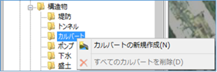 Figure: Calvert
Table: Culvert context menu items and functions
| Context menu items | function |
|---|---|
| Creating a New Culvert | Create a new culvert or siphon. |
| Remove all culverts | Remove all culverts or siphons. |
Creating a New Culvert
-
Mouse click the start and end points on the map to specify the extent.
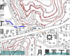
Figure: Creating a New Calvert (Ranged) -
To revert to the previous state, right-click or[BackSpace] press the key.
-
To cancel the creation,[Esc] press the key.
-
Double-click or [Enter] press the Press to confirm.
-
Set the conditions related to culverts on the Properties screen.
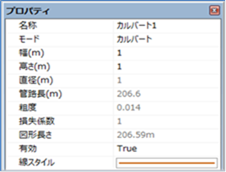
Figure: Properties screen for creating a new culvert.Table: New culvert property names and settings
| Property Name | What to set |
|---|---|
| name | Enter a name of your choice. |
| mode | Select the operating mode. The default value is "culvert". "Calvert": Calvert "Square Siphon": Rectangular tube siphon " Round Siphon": Circular section tube siphon |
| Width (m) | Sets the width of the culvert. Specify a value that is smaller than the mesh size to be calculated. The default value is "1". |
| Height (m) | Sets the height of the culvert. Specify a value that is smaller than the mesh size to be calculated. The default value is "1". |
| Diameter(m) | When the mode is "Maru Siphon", set the diameter. The default value is "1". |
| Pipeline length(m) | In corner and round siphon mode, set the length of the tube. The initial value is the length specified on the map. |
| Roughness | In corner and round siphon mode, set the roughness of the tube. The default value is "0.014". |
| Loss factor | In corner and round siphon mode, set the loss factor of the tube. The default value is "1". |
| Figure length | Displays the length of the specified culvert on the map. |
| valid | Enable/disable settings. The initial value is True. True: Enabled: False: Disabled |
| Line Style | Specify the line style (line type/line width/line color) to be displayed on the map. The initial values are as follows: Linetype: Solid Line Width: 2px Linecolor: RGB (200,100,0) |
Remove all culverts
When you select the menu, a confirmation message appears. [Yes] Click the button to delete all culvert data.
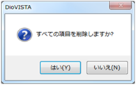 Figure: Remove all culverts.