FAQ/ Give a water level time series at the downstream end of a river
Can rivers be given downstream water levels over time?
response
It's possible.
Specify a water level time series as the river property.
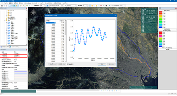 Figure: Downstream water level setting screen
Click in the river properties [Downstream water level] and enter the water level time series in the dialog that appears.
You can also [import] import data in CSV format by pressing the button in this dialog.
Here is an example of a CSV file that can be imported:
1 2 3 | |
The CSV format is as follows.
- Column A: Time(s)
- Row B: Water Level (m)
The data is handled as follows:
- Before the first time in the data, the value of the first time is used.
- After the last time in the data, the value of the last time is used.
- Times within a range of data use the values in the data that are linearly interpolated.
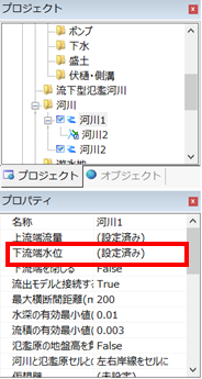
If you set the downstream water level, the River Properties [Downstream water level] [(Configured)] displays .
If not specified, [(Not set)] is displayed. If not specified, the downstream end will be a paragraph flow.
The downstream flow rate is determined by the following procedure.
The software employs a staggered grid for the river model. depth[N] is the water depth in cell N and discharge[N+1/2] is the flow rate between cell N and its downstream neighbor N+1. For paragraphs, depth[N] assume paragraphs from to discharge[N+1/2] find . If the downstream water level is specified, depth[N] is given as a boundary condition and is discharge[N-1/2] calculated by the indeterminate flow calculation. In this case, discharge[N+1/2] is discharge[N-1/2] a copy of .