Project/ Flow Rate
Main applications
- When levees are represented by elevation, overtopping and breaches can be simulated easily.
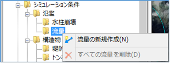 Figure: Flow rate
Table: Flow Context Menu Items and Functions
| Context menu items | function |
|---|---|
| Create a new flow rate | Create a new flow rate. |
| Remove all flow rates | Remove all flow rates. |
Create a new flow rate
-
Specify the section on the map where you want to output the flow rate with a mouse click.
Specify the interval with a line.
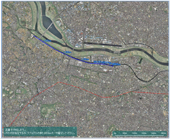
Figure: Creating a new flow rate -
To revert to the previous state, right-click or[BackSpace] press the key.
-
To cancel the creation,[Esc] press the key.
-
Confirm with double click or enter.
-
Set the flow rate conditions on the properties screen.
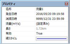
Figure: Properties screen for flow conditionsTable: Property names and settings for flow conditions
| Property Name | What to set |
|---|---|
| name | Enter a name of your choice. |
| Date and time of occurrence | Specify the date and time when the flow starts. The initial value is the date and time of the project. |
| Date and time of extinction | Specify the date and time when the flow rate disappears. The default value is "9999/12/31 23:59:59". |
| Flow rate (m^3/s) | Set the flow rate for time(s) change on the flow rate setting screen. |
| length | Displays the length of the specified section on the map. |
| valid | Enable/disable settings. The initial value is True. True: Enabled: False: Disabled |
| Line Style | Specify the line style (line type/line width/line color) to be displayed on the map. The initial values are as follows: Linetype: Solid Line Width: 2px Line Color: Blue |
Remove all flow rates
When you select the menu, a confirmation message appears.
[Yes] Click the button to delete all flow data.
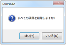 Figure: Remove all flow rates
Last update:
2023-03-20