FAQ/ I want to import topography, roughness, and embankment data in NetCDF format
Technical Reference Input/Output function/ Terrain, roughness, and embankment import function/ NetCDF format What are the tools and methods for creating netCDF files?
response
There are several ways to create a netCDF.
- How to convert a text file to netCDF format using a tool called ncgen.exe
- How to export mesh data in ASC format using GIS software such as QGIS and netCDF format using programming languages such as PowerShell
Here we will talk about the first method. The second method can be found here.
-
Install the netCDF library.
Get the netCDF4 64-bit version from the Installing and Using netCDF-C Libraries in Windows website of the official NetCDF website.
The latest version as of October 2021 is netCDF4.8.0-NC4-64.exe.
The following instructions assume that this version 4.8.0 is installed.
By defaultC:\Program Files\netCDF 4.8.0\, the netCDF library is installed. -
Create the data.
Here is some sample data: This is a format known as the CDL format. The CDL syntax is defined in NetCDF User's Guide - CDL Syntax.1 2 3 4 5 6 7 8 9 10 11 12 13 14 15 16 17 18 19 20 21 22 23 24 25 26 27 28 29 30 31 32 33 34 35 36 37 38 39 40 41 42 43 44 45 46 47 48 49 50 51 52 53 54 55 56 57 58 59 60 61 62 63 64 65 66 67 68 69 70 71 72 73 74 75 76 77 78 79 80 81 82 83 84 85 86 87 88 89 90 91 92 93
netcdf test { dimensions: lon = 9; lat = 15; variables: short lon(lon); lon:add_offset = 140.00015625; lon:scale_factor = 0.0003125; lon:units = "degrees_east"; short lat(lat); lat:add_offset = 36.000104166666666666666666666667; lat:scale_factor = 0.000208333333333333333333333333; lat:units = "degrees_north"; int glev(lat, lon); glev:valid_min = -100000; glev:valid_max = 1000000; glev:scale_factor = 0.01; glev:units = "m"; short roughness(lat, lon); roughness:scale_factor = 0.001; roughness:units = "m\^(-1/3).s"; int leveeHeight(lat, lon); leveeHeight:valid_min = -100000; leveeHeight:valid_max = 1000000; leveeHeight:scale_factor = 0.01; leveeHeight:units = "m"; byte leveeFlag(lat, lon); leveeFlag:flag_meanings = "east north"; leveeFlag:flag_masks = 1b, 2b; data: lon = 0, 1, 2, 3, 4, 5, 6, 7, 8; lat = 14, 13, 12, 11, 10, 9, 8, 7, 6, 5, 4, 3, 2, 1, 0; glev = 100, 100, 100, 100, 100, 100, 100, 100, 100, 100, 109, 116, 121, 122, 121, 116, 109, 100, 100, 117, 131, 140, 143, 140, 131, 117, 100, 100, 124, 144, 158, 162, 158, 144, 124, 100, 100, 130, 155, 172, 178, 172, 155, 130, 100, 100, 135, 164, 183, 190, 183, 164, 135, 100, 100, 137, 169, 190, 198, 190, 169, 137, 100, 100, 138, 171, 192, 200, 192, 171, 138, 100, 100, 137, 169, 190, 198, 190, 169, 137, 100, 100, 135, 164, 183, 190, 183, 164, 135, 100, 100, 130, 155, 172, 178, 172, 155, 130, 100, 100, 124, 144, 158, 162, 158, 144, 124, 100, 100, 117, 131, 140, 143, 140, 131, 117, 100, 100, 109, 116, 121, 122, 121, 116, 109, 100, 100, 100, 100, 100, 100, 100, 100, 100, 100; roughness = 30, 30, 30, 30, 30, 30, 30, 30, 30, 30, 30, 30, 30, 30, 30, 30, 30, 30, 30, 30, 30, 30, 30, 30, 30, 30, 30, 30, 30, 30, 30, 30, 30, 30, 30, 30, 30, 30, 30, 30, 30, 30, 30, 30, 30, 30, 30, 30, 30, 30, 30, 30, 30, 30, 30, 30, 30, 30, 30, 30, 30, 30, 30, 30, 30, 30, 30, 30, 30, 30, 30, 30, 30, 30, 30, 30, 30, 30, 30, 30, 30, 30, 30, 30, 30, 30, 30, 30, 30, 30, 30, 30, 30, 30, 30, 30, 30, 30, 30, 30, 30, 30, 30, 30, 30, 30, 30, 30, 30, 30, 30, 30, 30, 30, 30, 30, 30, 30, 30, 30, 30, 30, 30, 30, 30, 30, 30, 30, 30, 30, 30, 30, 30, 30, 30; leveeHeight = 0, 0, 0, 0, 0, 0, 0, 0, 0, 0, 0, 0, 0, 0, 0, 0, 0, 0, 0, 0, 0, 0, 0, 0, 0, 0, 0, 0, 0, 0, 0, 0, 0, 0, 0, 0, 0, 0, 0, 0, 0, 0, 0, 0, 0, 0, 0, 0, 0, 0, 0, 0, 0, 0, 0, 0, 0, 0, 0, 0, 0, 0, 0, 0, 0, 0, 0, 0, 0, 0, 0, 0, 0, 0, 0, 0, 0, 0, 0, 0, 0, 0, 0, 0, 0, 0, 0, 0, 0, 0, 300, 300, 300, 300, 300, 0, 0, 0, 0, 0, 0, 0, 0, 300, 0, 0, 0, 0, 0, 0, 0, 0, 300, 0, 0, 0, 0, 0, 0, 0, 0, 300, 0, 0, 0, 0, 0, 0, 0, 0, 300, 0, 0, 0, 0; leveeFlag = 0, 0, 0, 0, 0, 0, 0, 0, 0, 0, 0, 0, 0, 0, 0, 0, 0, 0, 0, 0, 0, 0, 0, 0, 0, 0, 0, 0, 0, 0, 0, 0, 0, 0, 0, 0, 0, 0, 0, 0, 0, 0, 0, 0, 0, 0, 0, 0, 0, 0, 0, 0, 0, 0, 0, 0, 0, 0, 0, 0, 0, 0, 0, 0, 0, 0, 0, 0, 0, 0, 0, 0, 0, 0, 0, 0, 0, 0, 0, 0, 0, 0, 0, 0, 0, 0, 0, 0, 0, 0, 2, 2, 2, 2, 3, 0, 0, 0, 0, 0, 0, 0, 0, 1, 0, 0, 0, 0, 0, 0, 0, 0, 1, 0, 0, 0, 0, 0, 0, 0, 0, 1, 0, 0, 0, 0, 0, 0, 0, 0, 1, 0, 0, 0, 0; }- Here's an example of creating data with latitude and longitude in the lower left corner (36.0 deg, 140.0 deg), 9 cells wide, 15 cells high, and a mesh size of 25 m in latitude and longitude coordinates.
- The data is 9 cells wide and 15 cells high. Give these values
lonto andlat(lines 3~4). - A mesh size of 25 m for latitude-longitude coordinates corresponds to a resolution of 1/3200 = 0.0003125 deg for longitude and 1/4800 = 0.000208333333333333333333333333333333333333333333333333333333333333333333333333333333333333333333333333333333333333333333333333333333333333333333333333333333333333333333333333333333333333333333333333333333333333333333333333333 Give these values
lon:scale_factorto and respectivelylat:scale_factor(lines 8 and 12). (Reference: Relationship between mesh size and latitude-longitude resolution) - Lower left longitude 140.0 plus longitude resolution multiplied by 1/2 and
lon:add_offsetgiven to (line 7). It also adds the lower-left latitude of 36.0 multiplied by 1/2 of the latitude resolutionlat:add_offsetand gives to (line 11). Note that the reason why only 1/2 cells are shifted to the upper right in this way is that netCDF gives the value of the center of the cell. - Line 31 gives a sequence of numbers that increases by 1, starting from 0 and ending with the number of horizontal cells - 1.
- The 32nd row gives a sequence of vertical cells - a number that decreases by 1, starting with 1 and ending with 0.
- Line 33 ~ stores the elevation data (m) multiplied by 100
glevin . Top left, upper right, bottom left, bottom right, separated by commas (,). There are 9 cells wide and 15 vertical cells, so the values for 45 cells are lined up here. There is no need for a line break after the comma. Write a semicolon () after the last value;. Note that the reason for multiplying the elevation data by 100 is that the value stored hereglev:scale_factormust be a reciprocal multiple of . - Line 48~, stores the roughness data multiplied by 1000
roughnessin . - Line 63 ~ stores the embankment top (m) multiplied by 100
leveeHeightin . - Line 78~, stores the levee flag
leveeFlagin . If you do not make an embankment, if you make an0embankment on the east side of the cell1, if you make it on the north side2, if you make it on the east and north3side, give it. Note that has a atleveeFlag:flag_masksthe end of the numberb. Thisbytemeans (signed 8-bit integer).
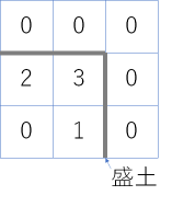
Figure:leveeFlagPositional relationship between the embankment and - Save the created data to your desktop with the file name sample.cdl.txt.
-
Convert using the tool ncgen.exe included with the netCDF library.
By default,C:\Program Files\netCDF 4.8.0\bin\ncgen.exeit is stored in .
From the command promptcmd.exe, call the following command:1 2
cd %USERPROFILE%\Desktop
"C:\Program Files\netCDF 4.8.0\bin\ncgen.exe" -b -k 4 sample.cdl.txt
is created on your desktop sample.cdl.nc .
-
Bring the created netCDF into DioVISTA.
- Launch DioVISTA.
-
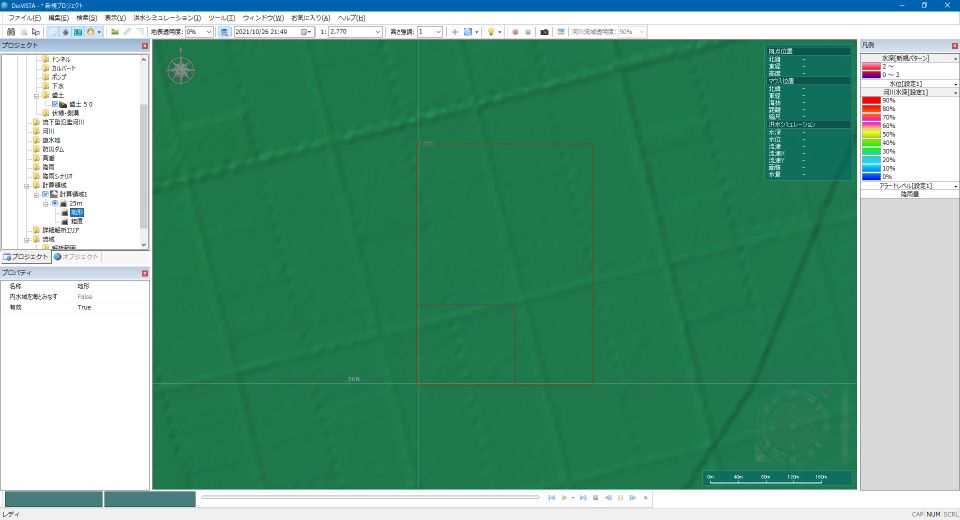
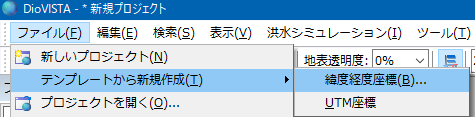
Select Menu [file] > > [Create new from template] [Latitude and longitude coordinates] >.
-
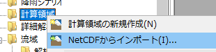
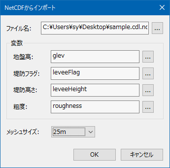
Select Project > [Calculation area] > [Import from NetCDF] .
-
Specify for the file name of the dialog that appears
sample.cdl.nc.
Specify a mesh size of 25 m.
- Data has been ingested into DioVISTA.