FAQ/ What is UTM Coordinate System?
What is a UTM coordinate system?
response
A type of map projection.
UTM coordinate system is an abbreviation for Universal Transverse Mercator coordinate system.
The UTM coordinate system expands as follows:
- 60 divisions in 6 degrees in the latitudinal direction
- Divided into two at the equator in the latitudinal direction (Northern Hemisphere, Southern Hemisphere)
The UTM zone numbers around Japan are shown in the figure.
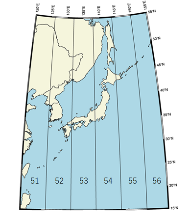 Figure: UTM zones around Japan
For example, the eastern Japan is UTM Zone 54N, with an origin of 0° north latitude and 141° east longitude.
The western Japan is UTM Zone 53N, with an origin of 0°N and 135°E.
Kyushu and Okinawa are located in UTM Zone 52N with origins at 0°N and 129°E.
If you select UTM coordinates, a square mesh is created.
For example, if you select a mesh size of 100m, you will have a square 100m mesh.
Here, "square" refers to the case where the four points of the mesh are represented in the UTM coordinate system (WGS84). If you specify a point in latitude and longitude and measure the distance or angle between the points, the values will be slightly different for different projected coordinate systems and coordinate reference systems (CRS).