Project/ Properties
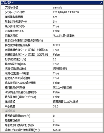 Figure: Project properties.
Table: Project property items and descriptions
| No. | Property Items | explanation |
|---|---|---|
| 1 | Project name | Set the project name. |
| 2 | Simulation date and time | Set the start date and time for the simulation. |
| 3 | Cross-sectional acquisition interval | [Edit a cross-section] > [Terrain acquisition] sets the interval at which terrain is retrieved and the mesh size of the DEM to use. The default value is 50m. Reference: FAQ/ Cross-sectional acquisition interval and target topographic data |
| 4 | Topographic data of interest | Set the mesh size of the DEM to be used when obtaining the elevation of the shape with the following functions. The default value is 50m. Target function- Fushi gutter / gutter - Drainage station - Embankment - River - Sewage reference: FAQ/ Cross-sectional acquisition interval and target topographic data |
| 5 | Exclude seas/rivers | Sets the handling of ocean areas in the flood model. The ocean is the cell on which the Sea flag is standing (see Project / Calculation area / Topography, roughness, porosity, transmittance X and transmittance Y). - [True]: Calculated excluding the ocean. When water enters the sea, it disappears. - [False]: Flood calculation is performed by considering the sea as land at an altitude of 0 m. (Default) |
| 6 | Exclude inland water surface | Sets the handling of river areas in the flood model. A river area is a cell with a River flag. - [True]: The river is considered to have a Sea flag. - [False]: Rivers are considered land. The elevation value is based on Geospatial Information Authority topographic data (basic survey, etc., 10m mesh), which is estimated from the surrounding elevation value. (Default) Reference: FAQ/ What is the River flag cell of terrain data? |
| 7 | Flood equation | Select the equation to use when calculating flooding. - [Linear format (Ver2.6 compatible)] : Indefinite flow equation without advection term. Option for maintaining compatibility with Ver2.6 - [PWRI (Ver2.6 compatible)] : Irregular flow equation conforming to PWRI Flood Simulation Manual (Draft) (February 8). Option for compatibility with Ver2.6 - [Linear] : Indefinite flow equation without advection term. Speed up using CPU extension instruction "SSE". (Default) - [With advection term] : An indefinite flow equation with an advection term. - [Manual 4th Edition Compliant] : Irregular flow equation according to "Ministry of Land, Infrastructure, Transport and Tourism Flood Inundation Area Map Creation Manual (4th Edition) July 27". Speed up using CPU extension instruction "SSE". Reference: Technical Reference/ Flood Model/ Basic Formula |
| 8 | Time to switch to wastewater-only assessment | Set the time(s) at which the flood calculation is aborted. From the set time, the flood calculation will be aborted and only the drainage will be calculated. Since the equations of motion and continuity equations of the river model are solved, the effect of drainage by drainage stations is evaluated. Reference: Technical Reference/ Flood Model/ Speeding up the Drainage Process |
| 9 | Building resistance coefficient per length | Set the building resistance coefficient per length. Valid only when "Manual 4th Edition Compliant" is selected as the flood equation. The default value is 0.383. This is the value described in "Ministry of Land, Infrastructure, Transport and Tourism Flood Inundation Area Map Preparation Manual (4th Edition) July 27". Reference: Technical Reference/ Flood Model/ Building Resistance Coefficient per Length |
| 10 | Calculate the home collapse risk zone (flooding) | Set up the implementation of the calculation of the flood flow house collapse risk zone. The fluid force is calculated from the flow velocity and inundation depth according to the setting of the house collapse risk zone due to flood flow in "Ministry of Land, Infrastructure, Transport and Tourism Flood Inundation Area Map Creation Manual (4th Edition) July 27". Regarding the calculation conditions, it is necessary to set the transmittance and porosity settings and flood conditions because they are not automatically changed. - [True]: Calculate. - [False]: Do not calculate. (Default) Reference: Technical Reference/ Flood Model/ Risk of House Collapse |
| 11 | Log the house collapse risk zone (flooding) | In calculating the danger zone for house collapse, the water depth and flow velocity (u,v) information when the danger is determined are output to dfsCalc.log. - [True]: Output. - [False]: Do not output. (Default) Reference: Technical Reference/ Flood Model/ Risk of House Collapse |
| 12 | Censored flow velocity (m/s) | Sets the maximum flood velocity. The default value is[10] . If it exceeds the maximum, force it to be rounded down to the maximum value. If you want to disable it, leave it unset. Reference: Technical Reference/ Flood Model/ Censored Flow Rate |
| 13 | tolerates negative water depth | Sets whether the source model allows negative depths to occur when water moves between different models. If you are dealing with overflow from a gutter that is narrower than the mesh size of the flood model,[False] set . This increases the accuracy of the calculation, but increases the calculation time. - [True]: Tolerates the occurrence of negative water depths. (Default) - [False]: Automatically shortens the time step* to avoid negative water depths. * Time step = volume of water in the cell of the model from which water moved / flow rate of water moving * 1 / 100 |
| 14 | Connecting rivers and floodplains | Sets the data that rivers and floodplains use for connections. - [Use distance markers] : Use a distance marker. (Default) - [Using the riverbank line] : Use the riverbank line. Reference: Technical Reference/ River Model/ Setting up connections for rivers and floodplains |
| 15 | Integrated analysis of rivers and floodplains | Set whether to connect rivers and floodplains to perform calculations. - [True]: Calculated by connecting rivers and floodplains. (Default) - [False]: Only rivers are calculated without connecting rivers and floodplains. |
| 16 | Applying the HQ formula to confluences | When referring to the water level of the main river from a tributary, apply or set the HQ formula. - [True]: HQ applied water level is used. (Default) - [False]: The water level before HQ is applied. Reference: Technical Reference/ River Model/ Correcting the water level with the HQ formula |
| 17 | Application of HQ formula to drainage destination river | Set the HQ formula for the water level of the drain destination river. The default value is "False". True: The HQ applied water level is used. False: The water level before HQ is applied. |
| 18 | Valid value of Himon Shiki height | Set the effective value of the Himonshiki height. - : The value specified for [Always user-specified value]Himon data [Ground height of the gutter opening] is a valid value. (Default) - [Auto-select maximum value]: Ground height of water intake location,[Ground height of the gutter opening] Compare the value specified for , and the higher value becomes the effective value. Reference: Technical Reference/ Boundary Conditions/ Drainage Station |
| 19 | HQ formula applies only to positive flow rate | Set the negative flow rate of the HQ formula. The default value[False] is (also applies to negative flow rates). Reference: Technical Reference/ River Model/ Correcting the water level with the HQ formula |
| 20 | Backward compatibility (embankment index) | Determine the handling of the embankment index in the river channel cross-section. The default value is[False] (not backward compatible). Unless you have a specific reason to do so, this value [False] should be . |
| 21 | transverse flow type | Make settings related to the transverse overflow type. - [Compliant with the Economic Research Manual]: Use a formula that conforms to the "Ministry of Land, Infrastructure, Transport and Tourism River Bureau Flood Control Economic Survey Manual (Draft) April 17". (Default) Embankment normal direction component: \(Q_N = \alpha Q_0 \cos \theta\) embankment tangential direction component: \(Q_S=0\) - [Manual 4th Edition Compliant]: Use a formula that conforms to the "Ministry of Land, Infrastructure, Transport and Tourism Flood Inundation Area Map Preparation Manual (4th Edition) July 27". Embankment normal directional component: \(Q_N = \alpha Q_0 \cos \theta\)embankment tangential direction component: \(Q_S = \alpha Q_0 \sin \theta\)- : 堤normal directional component: \(Q_[Squared]<br>N=\alpha Q_0 \cos^2 \theta\) Embankment tangential constituents: \(Q_S = \alpha Q_0 \sin^2 \theta\) Reference: Technical Reference/ River Model/ Overflow coefficient setting |
| 22 | UTM Zone | Sets the zone number of the UTM used by the model. [Calculation area] , the zone that contains the center of the calculation area is set. [Calculation area] , the zone is set to contain the central longitude of the simulation shape being calculated. Reference: Technical Reference/ Model Control/ Spatial Coordinates |
| 23 | Rainfall in clear weather | Hypothetical rainfall (rainfall on sunny days) is set so that the river flow rate does not reach zero even if the state of no rainfall continues. If it is set to a separate river, it is not used. The default value is[0] . |
| 23 | Rainfall correction magnification | Sets the correction factor to apply to rainfall. It is used when making so-called "stretching" of rainfall. If it is set to a separate river, it is not used. The default value is[1] . Reference: FAQ/ How to set the rainfall correction magnification |
| 25 | Terminate at lowest intake elevation | Sets the analysis extent for the watershed analysis. - [True]: Terminate the watershed search at the downstream end of the river. - [False]: Do not censor. Conduct watershed analysis up to the sea. (Default) |
| 26 | Minimum basin area of the runoff model (m2) | Specifies the minimum watershed area when using the spillover model. The default value is [62500] . The runoff model is used when the basin is larger than 250 m square. Reference: Technical Reference/ Spillage Model/ Implementation |
Last update:
2023-03-20