FAQ/ Roughness Factor Data Source
What data are you using as roughness data?
response
The roughness coefficient is set based on the land use data. Land use data is based on national land numerical information (or GLCC) data. The conversion method is user-definable. For each land-use category, you can specify the roughness factor, building occupancy, infiltration capacity, initial loss, and roughness of the runoff model for the flood model.
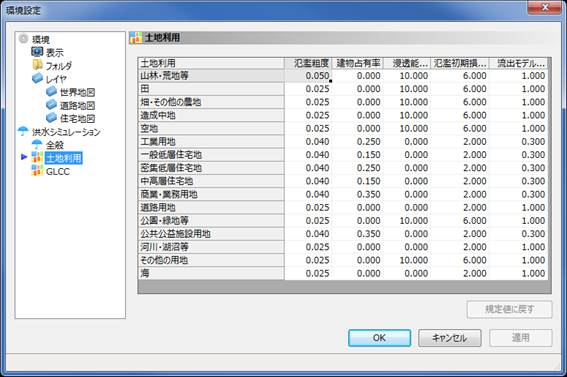 Figure: Land Use and Roughness Conversion Table
Data from Heisei 28 is used for domestic land use. For details, please refer to the Technical Reference Map Data accompanying DioVISTA. However, "roads" and "railways" added in the data of Heisei 21 are assigned to "road land", and "golf courses" are assigned to "parks, green spaces, etc."
The code of land use data of national land numerical information and the correspondence of DioVISTA classification code to it are shown below. The code of the national land numerical information is different between "Showa 51, 62, Heisei 3, 9, 18" and "Heisei 21, 26, 28", but DioVISTA uses the code after Heisei 21.
| DioVISTA Classification Code | classification | National Land Numerical Information Classification Code |
|---|---|---|
| 1 | Forests, wastelands, etc. | 500, 600 |
| 2 | field | 100 |
| 3 | Farmland and other farmland | 200 |
| 4 | Land under development | |
| 5 | Open space | |
| 6 | Industrial site | |
| 7 | General low-rise residential area | 700 |
| 8 | Densely populated low-rise residential area | |
| 9 | Medium- and high-rise residential areas | |
| 10 | Commercial and commercial land | |
| 11 | Road land | 901, 902 |
| 12 | Parks, green spaces, etc. | 1600 |
| 13 | Land for public utilities | |
| 14 | Rivers, lakes, etc. | 1100 |
| 15 | Other sites | 300, 400, 800, 1000, 1200, 1300 |
| 16 | sea | 1400, 1500 |