Project/ Tunnel
Main applications
- This setting is set when the movement of water by a culvert or the like is simply expressed in a floodplain.
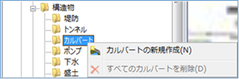 Figure: Tunnel
Table: Tunnel context menu items and functions
| Context menu items | function |
|---|---|
| Create a new tunnel | Create a new tunnel. |
| Delete All Tunnels | Delete all tunnels. |
Create a new tunnel
-
Mouse click the start and end points on the map to specify the extent.
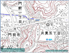
Figure: Creating a new tunnel (scoped) -
To revert to the previous state, right-click or[BackSpace] press the key.
-
To cancel the creation,[Esc] press the key.
-
Double-click or [Enter] press the Press to confirm.
-
Set the conditions related to the tunnel on the properties screen.
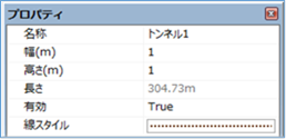
Figure: Properties screen for creating a new tunnelTable: New tunnel property names and settings
| Property Name | What to set |
|---|---|
| name | Enter a name of your choice. |
| Width (m) | Sets the width of the tunnel. Specify a value that is smaller than the mesh size to be calculated. The default value is "1". |
| Height (m) | Sets the height of the tunnel. Specify a value that is smaller than the mesh size to be calculated. The default value is "1". |
| length | Displays the length of the specified tunnel on the map. |
| valid | Enable/disable settings. The initial value is True. True: Enabled: False: Disabled |
| Line Style | Specify the line style (line type/line width/line color) to be displayed on the map. The initial values are as follows: Line Type: dotted Line Width: 2px Line Color: RGB (100,50,0) |
Delete All Tunnels
When you select the menu, a confirmation message appears. [Yes] Click the button to delete all tunnel data.
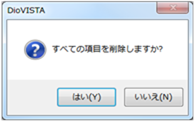 Figure: Delete all tunnels
Last update:
2023-03-20