Other/ About the handling of maps
When posting screenshots of the Software in printed materials or on websites, please follow the instructions below. You cannot use a part of the screen by cropping it. If map data is shown in the screenshot of this software, in addition to this description method, please follow the description method described in "When map data is shown" below.
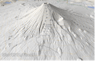
Diagram showing the entire operation screen or [snapshot] output using buttons
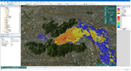 Example diagram showing the entire operating screen
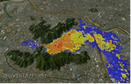
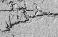
[snapshot] Example of a diagram output using a button
Example of source description (Japanese)
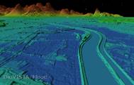
Figure 3 was created using DioVISTA/ Flood Version 3.1 Professional Edition from Hitachi Power Solutions Co., Ltd.
Example of citation
We used DioVISTA/ Flood Version 3.1 Professional Edition (Hitachi Power Solutions Co., Ltd.) to create Figure 3.
- ****Please rewrite the bold part (figure number, version number, edition name) according to the actual situation.
- The numbers in the figure are examples and should indicate the parts of the Software that have been used, such as Chapter 3, This Report.
When posting screenshots in printed materials, websites, etc. with map data in them
View satellite imagery
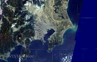 Example of displaying satellite imagery
Examples of citations (Japanese, English)
Blue Marble: Next Generation courtesy of NASA Earth Observatory. Landsat image courtesy of the Global Land Cover Facility (GLCF). Using high-resolution digital topography data from NASA's Shuttle Radar Topography Mission (SRTM).
View maps and topographic maps
 View maps and topographic maps
Please include the following permission numbers in a colophon in a font of at least 8 points.
In preparing this map, with the approval of the Director of the Geospatial Information Authority of Japan, we used the numerical map 25000 (map image), the numerical map 50m mesh (elevation), and the numerical map 5m mesh (elevation) issued by the Geospatial Information Authority of Japan. (License number: Taira 17 General Messenger, No. 635)
When written in English, it is as follows.
This map is based on the Digital Map 25000 (Map Image) and Digital Map 50m Grid (Elevation) and Digital Map 5m Grid (Elevation) published by Geospatial Information Authority of Japan with its approval under the article 30 of The Survey Act. (Approval Number SOU-SHI No.635 2005)
Map and map display (GI Map)

 View the map of the Institute of Geography
Please include the following permission numbers in a colophon in a font of at least 8 points.
In preparing this map, with the approval of the Director of the Geospatial Information Authority of Japan, basic map information and electronic topographic maps (tiles) issued by the Geospatial Information Authority of Japan were used. (Approval No. 29, No. 641)
View land use
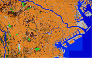 View land use
Please cite the source.
National Land Numerical Information (Land Use Mesh Data) Ministry of Land, Infrastructure, Transport and Tourism
When written in English, it is as follows.
National Land Numerical Information (Land utilization tertiary mesh Data) Japanese Ministry of Land, Infrastructure, Transport and Tourism