Project/ Rainfall Scenario
Main applications
- Used to specify mesh rainfall.
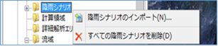 Figure: Rainfall scenario
Table: Context menu items and functions for rainfall scenarios
| Context menu items | function |
|---|---|
| Import rainfall scenarios | Import rainfall areas. |
| Remove all rainfall scenarios | Remove all rainfall scenarios. |
Import rainfall scenarios
-
When you select the menu, the folder selection dialog appears.
-
Specify the NetCDF file and[open] click the button.
-
Set the conditions related to rainfall scenarios on the properties screen.
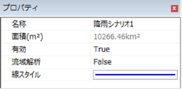 Figure: Rainfall scenario properties
Table: Rainfall scenario property names and settings
| Property Name | What to set |
|---|---|
| name | Enter a name of your choice. |
| Area (m^2) | Displays the area of the ingested extent. |
| valid | Enable/disable settings. The initial value is True. True: Enabled: False: Disabled |
| Line Style | Specify the line style (line type/line width/line color) to be displayed on the map. The initial values are as follows: Linetype: Solid Line Width: 2px Line Color: Blue |
Remove all rainfall scenarios
When you select the menu, a confirmation message appears. [Yes] Click the button to delete all rainfall scenario data.
Last update:
2023-03-20