Project/ Fushi / Gutter
Main applications
Set to represent drainage by pipes and ditches in the flood model.
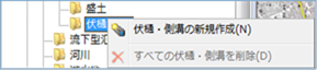 Figure: Fushi gutter and gutter
Table: Context menu items and functions for gutters
| Context menu items | function |
|---|---|
| Creating new gutters and gutters | Create a new gutter or gutter. |
| Remove all gutters | Remove all gutters and gutters. |
Creating new gutters and gutters
-
Specify the section on the map where you want to create a gutter with a mouse click.
Elevation data is sampled from the project's Terrain of Interest.
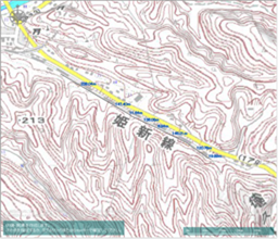
Figure: Creating a new gutter and gutter (section designation) -
To revert to the previous state, right-click or[BackSpace] press the key.
-
To cancel the creation,[Esc] press the key.
-
Double-click or [Enter] press the Press to confirm.
-
Set the conditions related to gutters and gutters on the property screen.
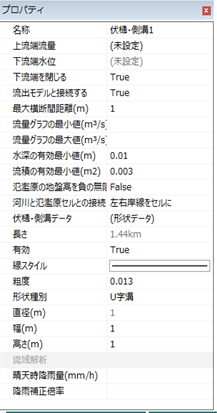
Figure: Properties screen of creating a new gutterTable: Property names and settings for creating new gutters
Property Name What to set name Enter a name of your choice. Upstream flow rate Set the upstream flow rate for time(s) change on the hourly upstream flow setting screen. Downstream water level When closing the downstream end is set to "False", the downstream end water level is set for the time(s) change on the hourly downstream water level setting screen. Close downstream end Sets the downstream state.
The initial value is True.
True: The downstream end is closed.
False: The downstream end is not closed.Connect with exfiltration models Set up a connection with the exfiltration model.
The default value is "True".
True: The gutter is connected to the spill model (if the Shape Type is U-Groove).
False: The gutter is not connected to the spillover model.Maximum cross-section distance (m) Specify the maximum cross-section distance. The standard is about the same as the width.
The default value is "1".Minimum value of flow graph (m^3/s) Set the minimum value of the vertical axis of the flow rate graph in the profile view of the river cross-sectional view screen.
The initial value is not set.Maximum value of flow graph (m^3/s) Set the maximum value of the vertical axis of the flow rate graph in the profile view of the river cross-sectional view screen.
The initial value is not set.Minimum effective water depth (m) Set the water limit depth.
The default value is "0.01". You can specify 0.0001~0.1.Minimum effective value of current product (m^2) Set the critical flow product.
The default value is "0.003". You can specify 0.0003~0.03.Considers the ground height of the floodplain to be negative infinity (does not flow in from the flood) Set the inflow conditions from flooding to the gutters and gutters.
The default value is "False".
True: Do not allow inflow from flooding.
False: Allow inflow from flooding.Connecting rivers with floodplains Set how rivers and floodplains are connected.
The default value is "Left and right coast lines in cells".
Left and Right Coastlines to Cells: Connected from the left and right coastlines to the floodplain.
Kawashin-Line to Cell Boundary: Connects from the riverline to the floodplain.
If the river core line is not set, the river center line is automatically determined from the left and right shore lines and connected.Fushi and gutter data On the gutter data editing screen, set the elevation of the selected location on the map. length Displays the length of the gutter specified on the map. valid Enable/disable settings.
The initial value is True.
True: Enabled:
False: DisabledLine Style Specify the line style (line type/line width/line color) to be displayed on the map.
The initial values are as follows:
Linetype:
Solid Line Width: 2px Linecolor:
RGB (200,100,0)Roughness Set the roughness factor.
The default value is "0.013".Shape type Set the shape "U-shaped groove" / "round tube".
The default value is "U-shaped groove".Diameter(m) If the shape is "round tube", set the diameter.
The default value is "1".Width (m) If the shape is "U-groove", set the width.
The default value is "1".Height (m) If the shape is "U-groove", set the height.
The default value is "1".Rainfall in clear weather When calculating the initial flow rate, set it as the rainfall intensity.
Calculated from the initial flow rate and basin area. The initial value is not specified.
Rainfall in clear weather = (Initial flow rate (m^3/s)/(Watershed area (km^2))×3.6Rainfall correction magnification If rainfall conditions are specified, set the rainfall correction magnification.
The initial value is not specified.
Remove all gutters
When you select the menu, a confirmation message appears. [Yes] Click the button to delete all gutter data.
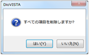 Figure: Removing all gutters