Project/ Water column collapse
Main applications
-
You can simulate the collapse of a water column of a specified height.
-
It is possible to verify that the law of conservation of mass is satisfied.
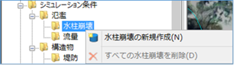 Figure: Water column collapse
Table: Water column collapse context menu items and functions
| Context menu items | function |
|---|---|
| Creating a new water column collapse | Create a new water column collapse. |
| Remove all water column collapses | Remove all water column collapses. |
Creating a new water column collapse
-
Specify the area where the water column collapses on the map with a mouse click.
Specify the range with a line. [Ctrl] When you press the key, you can specify the range with a rectangle.
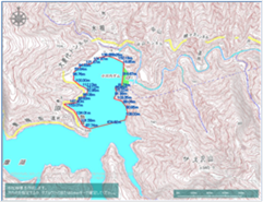
Figure: Specifying the extent of water column collapse -
To revert to the previous state, right-click or[BackSpace] press the key.
-
To cancel the creation,[Esc] press the key.
-
Double-click or [Enter] confirm with the key.
-
Set the conditions for water column collapse on the properties screen.
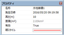
Figure: Properties screen for specifying conditions for water column collapse
Table: Property names and settings for water column collapse conditions
| Property Name | What to set |
|---|---|
| name | Enter a name of your choice. |
| Date and time of occurrence | Specify the date and time when the water column collapse begins. The initial value is the date and time of the project. |
| Height (m) | Enter the height information. The default value is 10m. |
| Area(\(m^2\)) | Displays the area of the specified extent on the map. |
| valid | Enable/disable settings. The initial value is True. True: Enabled: False: Disabled |
| Line Style | Specify the line style (line type/line width/line color) to be displayed on the map. The initial values are as follows: Linetype: Solid Line Width: 2px Line Color: Red |
Remove all water column collapses
When you select the menu, a confirmation message appears.
[Yes] Click the button to delete all water column collapse data.
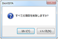 Figure: Delete all water column collapse data