Project/ River
Main applications
- This setting is set when calculating the river water level and calculating flooding due to overflow or collapse from the embankment.
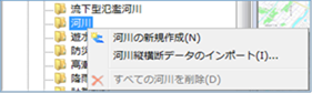 Figure: River
Table: River context menu items and functions
| Context menu items | function |
|---|---|
| Create a new river | Create a new river. |
| Import river cross-section data | Import rivers from river cross-section data. |
| Delete all rivers | Delete all rivers. |
Create a new river
-
When you select the menu, new stream data is created under the Rivers' folder.
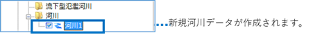
Figure: Create new stream data -
Set the settings related to river data on the property screen.
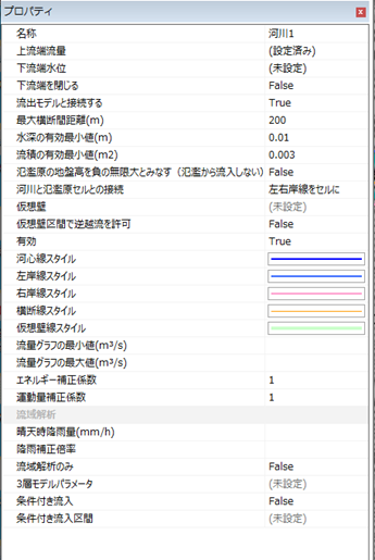
Figure: Properties screen of river data settings
Table: Properties screen and settings of river data settings
| Property Name | What to set |
|---|---|
| name | Enter a name of your choice. |
| Upstream flow rate | Set the upstream flow rate for time(s) change on the hourly upstream flow setting screen. The initial value is set to flow down 100m^3/s/s constant flow rate. |
| Downstream water level | Set the downstream water level for time(s) changes on the hourly downstream water level setting screen. The initial value is not set. |
| Close downstream end | Sets the downstream state. The initial value is False. True: The downstream end is closed. False: The downstream end is not closed. |
| Connect with exfiltration models | Set up a connection with the exfiltration model. The default value is "True". True—The stream is connected to the runoff model. False—The river is not connected to the runoff model. |
| Maximum cross-section distance (m) | Specify the maximum cross-section distance. The standard is about the same as the width of the river. The default value is "200". |
| Minimum effective water depth (m) | Set the water limit depth. The default value is "0.01". You can specify 0.0001~0.1. |
| Minimum effective value of current product (m2) | Set the critical flow product. The default value is "0.003". You can specify 0.0003~0.03. |
| Considers the ground height of the floodplain to be negative infinity (does not flow in from the flood) | Set conditions for the inflow of rivers from flooding. The initial value is False. True: Do not allow inflow from flooding. False: Allow inflow from flooding. |
| Connecting rivers with floodplains | Set how rivers and floodplains are connected. The default value is "Left and right coast lines in cells". Left and Right Coastlines to Cells: Connected from the left and right coastlines to the floodplain. Kawashin-Line to Cell Boundary: Connects from the riverline to the floodplain. If the river core line is not set, the river center line is automatically determined from the left and right shore lines and connected. |
| Virtual Wall | Build an infinite wall over the river and set up a section that does not overflow. The initial value is not set. |
| Allow reverse overflow in virtual wall sections | Set the conditions for inflow from flood to river from the virtual wall setting section. The initial value is False. True: Allow inflow from flooding. False: Do not allow inflow from flooding. |
| valid | Enable/disable settings. The initial value is True. True: Enabled: False: Disabled |
| Kawashin Line Style | Specify the river line style (line type/line width/line color) to be displayed on the map. The initial values are as follows: Line Type: Solid Line Width: 2px Line Color: RGB (0, 0,255) |
| Left Bank Line Style | Specify the left bank line style (line type/line width/line color) to display on the map. The initial values are as follows: Linetype: Solid Lineweight: 2px Linecolor: RGB(51,102,255) |
| Right bank line style | Specify the right bank line style (line type/line width/line color) to display on the map. The initial values are as follows: Linetype: Solid Line Width: 2px Line Color: RGB (255,153,204) |
| Section line style | Specify the section line style (line type/line width/line color) to display on the map. The initial values are as follows: Linetype: Solid Line Width: 2px Linecolor: RGB(255,153, 0) |
| Virtual wallline style | Specify the line style (line type/line width/line color) that represents the virtual wall to be displayed on the map. The initial values are as follows: Linetype: Solid Line Width: 4px Linecolor: RGB (204,255, 204) |
| Rainfall in clear weather | When calculating the initial flow rate, set it as the rainfall intensity. Calculated from the initial flow rate and basin area. The initial value is not specified. Clear weather rainfall = [Initial flow rate (m^3/s/s)] / [Watershed area (km^2)] * 3.6 |
| Rainfall correction magnification | If rainfall conditions are specified, set the rainfall correction magnification. The initial value is not specified. |
| Watershed analysis only | Enable for watershed analysis only. If watersheds are not analyzed as intended, create streams where they are affected. For example, if you do not want the upstream of the dam on the main river to be the watershed analysis range, and you enable only the watershed analysis as a separate river at the location of the dam, you can exclude the upstream part of the dam as a watershed analysis result of the main river. The initial value is false. True: Enabled: False: Disabled |
| Three-layer model parameters | Set the infiltration conditions when implementing a runoff model (calculation of flowing into a river from rainfall). Only forests and wastelands of land use are eligible. Other land-use items use the menu bar/Tools/Flood simulation/Land-use runoff model roughness parameters. For the contents of each parameter, please refer to the menu bar / Tools / Flood simulation / GLCC. |
| Conditional inflow | Set to enable the function of inflow rate from the runoff model to the river from the rainfall conditions. The initial value is false. True: Enabled: False: Disabled |
| Conditional inflow section | For each section of the river, the amount of rainfall (mm/h) and the inflow rate to start can be set for the inflow into the river from the basin or mountain stream. Watershed: Mountain stream smaller than the minimum watershed area of the runoff model (waterfall): You do not set an initial value that is greater than the minimum watershed area of the runoff model . |
| Minimum flow graph (m^3/s) | Set the minimum value of the vertical axis of the flow rate graph in the profile view of the river cross-sectional view screen. The initial value is not set. |
| Maximum value of flow graph (m^3/s) | Set the maximum value of the vertical axis of the flow rate graph in the profile view of the river cross-sectional view screen. The initial value is not set. |
| Energy correction factor | Sets the energy correction factor. The default value is "1". You can specify 0.1~3. |
| Momentum correction factor | Sets the momentum correction factor. The default value is "1". You can specify 0.1~3. |
Import river cross-section data
This is the same operation as importing a flowing flood river. Please refer to Importing River Data (Common to Flowing Flooded Rivers and Rivers).
Delete all rivers
When you select the menu, a confirmation message appears. [Yes] Click the button to delete all river data.
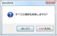 Figure: Delete all rivers.
Last update:
2023-03-20