FAQ/ The surface of the floodplain is not smooth
As a result of the maximum inundation depth, there are some areas where the water level is not smooth.
What is the cause?
response
It is thought that jumping water is occurring in places where the water surface is not gentle.
The project file you sent us had the following settings.
- Use flood models only
- Mesh size 5 m
- Provide a peak flow rate of 500 m3/s to areas with floodplains
- The slope of the analysis area is about 1/20 (quite steep)
- Set the roughness in the analysis area to n = 0.02 (low value for the roughness of the floodplain)
When we performed our analysis, the width of the inundation area was about 50 m at the peak flow rate of 500 m3/s. Therefore, the peak unit width flow rate is considered to be about 10 m2/s.
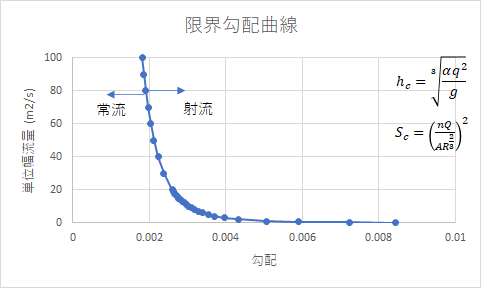
Based on these results, a limit slope curve was created (see figure below). The slope of the target area this time is about 1/20, that is, 0.05, so it corresponds to the right side of the graph far to the right (0.01). It is not strange that the current is constantly occurring.
Because of this, the current flow is more likely to occur in this analysis. It seems that the splash is caused by a slight slowness of the slope in the analysis area. In addition, the water surface shape is stable in time. This may suggest that this water surface shape does not arise from computational instability.