Project/ Drainage Area
Main applications
Set when there is a flood control effect from the river to the drainage area.
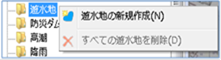 Figure: Drainage basin
Table: Drainage area context menu items and functions
| Context menu items | function |
|---|---|
| Creating a new drainage basin | Create a new drainage area. |
| Delete all reservoirs | Delete all drainage areas. |
Creating a new drainage basin
-
Specify the area on the map where you want to create a drainage basin with a mouse click.
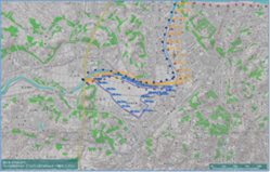
Figure: Specify the drainage area -
To revert to the previous state, right-click or[BackSpace] press the key.
-
To cancel the creation,[Esc] press the key.
-
Double-click or [Enter] key to confirm.
-
Set the conditions related to the drainage basin on the properties screen.
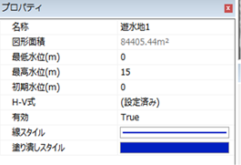
Figure: Properties screen of drainage area settingsTable: Reservoir property names and settings
Property Name What to set name Enter a name of your choice. Figure area (m^2) Displays the area of the specified shape on the map. Minimum water level (m) Specifies the minimum water level of the drainage area.
The initial value is 0.Maximum water level (m) Specifies the maximum water level of the drainage area.
The initial value is 15.Initial water level (m) Specifies the initial water level of the drainage area.
The initial value is 0.H-V On the H-V Formula Settings screen, define the relationship between the water level and the storage capacity. Initial water storage (m^3) Specify the initial reserve.
The default value is 0.Total water storage (m^3) Specify the initial reserve.
The default value is 0.Area (m^2) Specifies the area of the drainage area.
The default value is 0.valid Enable/disable settings.
The initial value is True.
True: Enabled:
False: DisabledLine Style Specify the line style (line type/line width/line color) to be displayed on the map.
The initial values are as follows:
Line Type: Solid
Line Width: 2px
Line Color: 0,32,192Fill style Specify the style (fill/color) for filling the extent on the map.
The initial values are as follows:
Fill: Fill
Color: 0,32,192
Delete all reservoirs
When you select the menu, a confirmation message appears. [Yes] Click the button to delete all reservoirs.
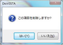 Figure: Delete all reservoirs.
Last update:
2023-03-20